Reality Capture for the Built Environment
Alpine delivers high-accuracy laser scanning and 3D documentation for design, construction, and facility projects across Utah and the Intermountain West
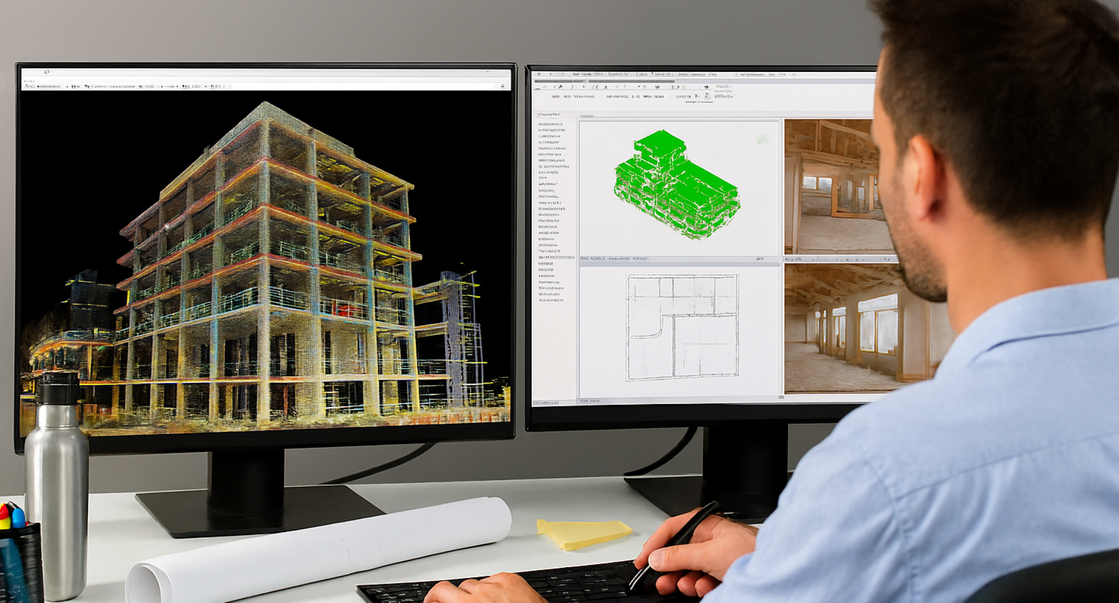
Our Technology
Alpine uses advanced ground-based and aerial reality capture systems to produce complete, georeferenced documentation tailored to your project’s scope, coordination needs, and schedule.
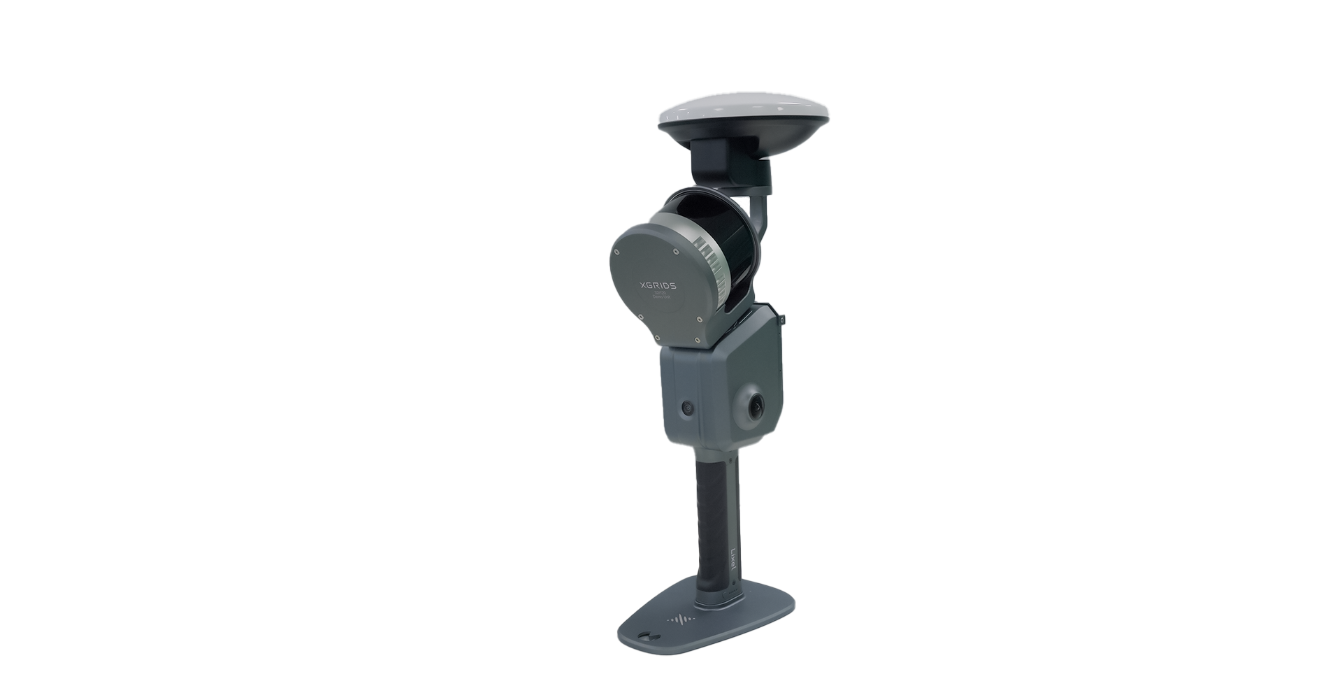
Real Time Handheld Capture
Our handheld SLAM scanners deliver dense point clouds with 1 mm point spacing and centimeter-level precision up to 400 feet. Each scan captures exceptional detail, 10x higher density than comparable systems, rivaling terrestrial laser scanners. Combined with RTK/PPK positioning, our workflow delivers consistent georeferenced data with minimal drift for seamless large-area documentation. Your design and coordination teams can confidently perform clash detection and validation from the office.
Aerial LiDAR & Photogrammetry
We combine LiDAR’s geometric precision with high-resolution aerial imaging to document sites, façades, and large structures. Integrated aerial and ground data produce cohesive datasets optimized for visualization, coordination, and design planning. Extended flight endurance allows full-site documentation in a single mobilization.
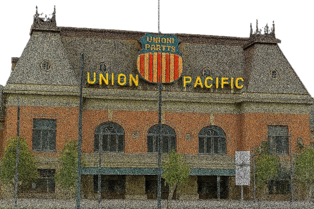
High Accuracy Static Laser Scanning
For engineering-critical applications, we use terrestrial laser scanners capable of millimeter-level precision, ideal for deformation tracking, tolerance verification, and structural documentation.
Photorealistic 3D Environments
Experience immersive, browser-based 3D walkthroughs that combine photorealistic visuals with dimensional accuracy. Dual 48 MP cameras and Gaussian Splatting (3DGS) technology deliver next-generation visualization—perfect for stakeholder engagement, design review, and remote collaboration.
Services for Architects
Design from Reality, Not Assumptions
Existing Conditions Documentation
Applications: Renovations, feasibility studies, code compliance
Deliverables: Point clouds (RCP, E57, LAS), 2D plans, dimensional reports
Accuracy: ±½″ – ±2″
Key Benefit: Rapid turnaround—typically within 48 hours—accelerates design while reducing site visits. Enables remote collaboration and multi-discipline coordination using clean, compatible datasets.
Scan to BIM (Architectural Modeling)
Applications: Base models, consultant coordination, permit sets
Deliverables: Revit models (LOD 200–350), IFC files, parametric content
Accuracy: ±¼″ – ±½″
Key Benefit: Improves early coordination and clash avoidance, reducing rework and expediting permitting. Provides accurate BIM data for lean, coordinated design.
AI-Accelerated Scan to BIM
Applications: Multi-unit housing, fast-track tenant improvements
Deliverables: AI-generated Revit models with smart object recognition
Accuracy: ±⅜″ – ±½″
Key Benefit: Reduces manual modeling time by up to 90%, delivering accurate BIM models fast—ideal for repeatable layouts and tight timelines.
Immersive Client Presentations
Applications: Stakeholder engagement, funding approvals, design reviews
Deliverables: Web-based 3D walkthroughs, no downloads required
Key Benefit: Transforms complex spatial data into clear, photorealistic 3D visuals accessible from any browser, improving communication and accelerating approvals.
Design Validation & Coordination Support
Applications: Fit checks, MEP coordination, conflict resolution
Deliverables: Issue annotations, deviation reports, variance visuals
Key Benefit: Enables proactive issue detection and resolution to keep projects aligned and on schedule.
Historical Documentation & Preservation
Applications: Restoration, seismic retrofit planning, heritage archiving
Deliverables: Point clouds, orthophotos, CAD sets
Accuracy: ±¹⁄₁₆″ – ±½″
Key Benefit: Produces archive-ready data with photorealistic texture for compliance and long-term preservation of historic assets.
Services for Engineers
Engineering-Grade Accuracy for Analysis & Design
Structural Documentation
Applications: Load path evaluation, deformation monitoring, retrofit design support
Deliverables: Registered point clouds, sectional views, structural geometry models
Accuracy: ±¼″ – ±1⁄₁₆″ (method dependent)
Key Benefit: Provides engineers with verified spatial data for load analysis, deformation assessment, and retrofit validation, supporting confident, data-driven design decisions.
MEP System Documentation
Applications: Mechanical routing, as-builts, tie-ins
Deliverables: LOD 300–350 Revit models, isometrics, clearance diagrams
Key Benefit: Improves coordination and reduces field measurement time in dense MEP environments.
Site Documentation (Non-Survey)
Applications: Grading coordination, parking layouts, site planning
Deliverables: Surface models, topographic references, cut/fill visuals
Key Benefit: Provides design-ready context for site coordination and earthwork planning ( informational only; not for survey use).
BIM Coordination & Clash Detection
Applications: Trade coordination, prefabrication validation, MEP and structural conflict detection
Deliverables: Clash reports, variance maps, Navisworks-compatible coordination models
Accuracy: ±¼″ – ±½″
Key Benefit: Identifies and resolves spatial conflicts early in the coordination phase—reducing rework, material waste, and schedule impacts while improving overall project efficiency.
Infrastructure & Industrial
Applications: Utility corridors, process plants, retrofits
Deliverables: Clearance models, isometrics, spatial verifications
Key Benefit: Delivers high-detail data for complex facilities and brownfield projects, supporting safe design and retrofit planning.
Services for Contractors
Eliminate Field Surprises, Document with Confidence
Pre Construction Validation
Applications: Existing condition verification, bid validation, prefabrication preparation
Deliverables: Dimensional checks, variance maps, coordination models
Accuracy: ±¼″ – ±½″
Key Benefit: Confirms site conditions before mobilization to minimize delays, reduce rework, and enable accurate prefabrication and installation.
Aerial Photogrammetry
Applications: Site visualization, progress tracking, preliminary volume estimation
Deliverables: High-resolution orthomosaics and 3D textured surface models
Accuracy: ≈ 1″ GSD with RTK/PPK referencing (for coordination use only; not a certified survey)
Key Benefit: Provides detailed aerial imagery and models that enhance coordination, communication, and project visualization across the team.
Construction Progress Documentation
Applications: Draw progress monitoring, payment verification, concealment recording
Deliverables: Time-stamped scans and milestone models
Accuracy: ±¼″ – ±½″
Key Benefit: Establishes objective, verifiable records for milestone tracking, payment support, and dispute resolution.
Renovation & Demolition Planning
Applications: Interior gutting, selective demolition, shoring and retrofit design
Deliverables: Structure maps, demolition limit models, scans of critical components
Accuracy: ±¼″ – ±½″
Key Benefit: Documents existing structural conditions to guide safe demolition and renovation, reducing risk and preventing costly on-site surprises.
As-Built Documentation
Applications: Turnover documentation, warranty support, future renovation planning
Deliverables: Registered point clouds, dimensional verification reports, digital twin datasets
Accuracy: ±¼″ – ±½″
Key Benefit: Delivers verified final-condition documentation within 48 hours—providing owners with reliable, measurable records for long-term facility management.
Volumetric and Mapping Support
Applications: Earthwork coordination, progress monitoring, preliminary material estimation
Deliverables: High-resolution orthomosaics, surface data, informational volume analyses
Accuracy: ≈ 1″ GSD (for coordination use only; not a certified survey)
Key Benefit: Supplies visual and quantitative insight for planning and progress evaluation, improving coordination and decision-making.
Quality Control Verification
Applications: Flatness and alignment checks, tolerance compliance, installation QA
Deliverables: Heat maps, deviation visuals, QA reports
Accuracy: ±¼″ – ±½″
Key Benefit: Detects dimensional deviations early, supporting continuous quality improvement and adherence to construction tolerances and schedules.
Services for Facility Management
Digital Asset Intelligence for Smarter Operations
Facility Baseline Documentation
Applications: CMMS integration, space inventory, long-term facility planning
Deliverables: Point clouds, BIM models (LOD 300–350), 2D floor plans
Accuracy: ±¼″ – ±½″
Key Benefit: Establishes a reliable digital foundation for strategic maintenance, asset management, and capital planning.
Space Planning & Utilization
Applications: Reconfiguration, ADA audits, tenant fit-outs
Deliverables: Floor plans, occupancy diagrams, circulation analyses
Accuracy: ±½″ – ±2″
Key Benefit: Enables fast, low-disruption evaluations for tenant improvements and compliance reviews, optimizing space and occupancy efficiency.
Capital Project Planning
Applications: Budgeting, feasibility studies, RFP preparation
Deliverables: Existing-condition records, scope visuals, area measurements
Accuracy: ±¼″ – ±½″
Key Benefit: Improves cost and schedule accuracy by basing early decisions on verified existing-condition data, reducing contingencies and redesigns.
Immersive Facility Records & Virtual Access
Applications: Remote facility management, staff training, insurance documentation
Deliverables: 360° browser-based walkthroughs and interactive 3D environments
Accuracy: ±½″ – ±2″
Key Benefit: Provides easy, remote access to photorealistic facility documentation for operations, maintenance, and stakeholder collaboration.
Property Marketing & Leasing
Applications: Investment marketing, leasing presentations, tenant visualization
Deliverables: Verified floor plans, 3D walkthroughs, virtual tours
Accuracy: ±½″ – ±2″
Key Benefit: Combines visual quality with measurement accuracy to accelerate leasing and investment decisions through interactive, high-impact digital presentations.
Our Deliverables
As a Utah-based provider, Alpine delivers high-accuracy reality capture with fast turnarounds and personalized service that integrates seamlessly into AEC workflows.
Our focus on clarity and responsiveness ensures your team has the data they need to reduce rework and accelerate project timelines.
Standard Deliverables
Registered Point Clouds: Ground-based and handheld LiDAR scans georeferenced with RTK positioning, delivered in RCP, E57, LAS, and LAZ formats compatible with Revit, AutoCAD, Navisworks, and Civil 3D.
Aerial Imagery & Point Clouds: High-resolution photogrammetry for visualization and design coordination.
BIM Models: LOD 200–400 Revit models and IFC files through experienced partner modelers.
2D Documentation: Plans, elevations, and sections derived from point cloud data.
Orthomosaic Maps & Surface Models: Geo-referenced visual maps and surface representations for design and coordination.
Photorealistic 3D Environments: Interactive, browser-based visualizations with dimensional accuracy.
Integrated Interior + Exterior Data: Unified datasets covering both building interiors and site context.
Panoramic Imagery: Spatially registered visual records for remote review and collaboration.
Volumetric & Earthwork Analysis: Preliminary material and progress assessments for coordination (use for reference only).
Data Formats & Compatibility
All deliverables are supplied in open, industry-standard formats for seamless AEC integration:
Point Cloud Formats: RCP, RCS, E57, LAS, LAZ, XYZ
BIM / CAD Formats: Revit (.rvt, .rfa), IFC, AutoCAD (.dwg, .dxf)
3D Formats: OBJ, FBX, STL (for visualization and modeling)
Image Formats: JPEG, TIFF (for panoramic and photogrammetric documentation)
Video Formats: MP4 (for walkthroughs, flyovers, and presentations)
Optional Enhanced Deliverables
AI-Accelerated BIM Models for faster model generation and QA.
Textured 3D Meshes for visualization and presentations.
3D Walkthroughs & Flyovers for project updates and marketing.
Property Marketing Packages combining accurate plans and virtual tours.
Delivery & Data Management
Flexible Turnaround Options
Local Wasatch Front projects: same-day scanning and point cloud delivery available when schedules demand.
Standard turnaround: 48 hours for registered point clouds.
Modeling timelines scale with project size and required Level of Detail (LOD).
Rush options available for time-sensitive projects.
Hosted Collaboration Platform
Secure project access via Autodesk Docs with real-time collaboration, comments, and version control.
Organized file structures maintain consistency across the project lifecycle.
Stakeholders can view and comment directly in the browser—no software installation required.
Offline Delivery Options
Complete data packages available for independent review and on-premise workflows.
No mandatory cloud dependency—ideal for sensitive or restricted projects.
Full client ownership and control of all deliverables, regardless of delivery method.
File Organization & Version Control
Professional naming conventions and folder structures ensure traceability.
Version history documents all project updates.
Annotation tools support coordination and issue tracking.
Why Choose
Alpine Reality Capture
Alpine provides precise ground and aerial documentation for architects, engineers, contractors, and building owners across Utah and the Intermountain West.
We operate safely, efficiently, and in coordination with construction protocols.
How We Work
Technology Matched to Requirements: Handheld scanning for coverage, static scanning for precision, aerial LiDAR and photogrammetry for site context. Every project uses the right tool for its needs.
Integrated Multi-Source Data: Ground and aerial datasets merge into consistent, georeferenced models for coordination without coverage gaps.
Professional Operations: FAA-licensed drone pilots, OSHA-10 certified field staff, and full insurance for active construction sites.
Clear Service Scope: Dimensional documentation for design and construction support only; not licensed surveying or boundary determination.
Service Model
Realistic Turnarounds: Same-day scanning available locally; standard 48-hour point cloud delivery.
Data Ownership: Clients retain full rights and editable formats.
Transparent Pricing: Quoted based on scope, accuracy, and deliverables.
Modeling Partnerships: Trusted Revit specialists ensure LOD 200–400 quality.
Satisfaction Guarantee: If deliverables don’t meet specifications, we recapture at no cost or refund in full.
FAQs
Where are you located and what areas do you serve?
We're based in Draper, Utah, serving the Wasatch Front and Wasatch Back locally. We travel regionally for larger projects or clients with multi-facility documentation requirements.
What accuracy do your scans provide?
Handheld scanning: ~1" accuracy to 300+ feet, with increased accuracy with our close proximity scanning, ensuring we cover ever detail. Static scanning: up to ⅛" for engineering-critical applications. Photogrammetry: typically 1-2.5" horizontal and 1-4" vertical accuracy with RTK/PPK integration, depending on flight parameters. We tailor accuracy specifications to your project phase and deliverable needs.
How is project data secured?
We provide you with options. Data can be processed and stored entirely on-premise, with no mandatory cloud exposure. For online collaboration, we use encrypted Autodesk Docs hosting with strict access controls. You maintain full ownership and control.
What if I'm not sure what level of service my project needs?
Contact us with your project goals. We'll recommend appropriate capture methods, accuracy specifications, and deliverables. We match technology to actual needs, not every application requires millimeter precision or point cloud expertise. Our goal is to give you everything you actually need, without paying for additional services that aren’t meaningful or helpful.
How experienced are your operators?
FAA certified for commercial drone operations. OSHA 10 certified for construction site safety. Extensive training in 3D laser scanning methodologies, point cloud processing, photogrammetry and AEC documentation standards. We understand construction sequencing, coordination requirements, and professional liability considerations. We partner with best in class modelers with extensive experience.
How quickly can you complete scanning?
Real time handheld systems capture most building interiors in under an hour. Combined with aerial documentation for exteriors and sites, comprehensive coverage happens in single-day mobilizations. Local projects can receive same-day point cloud delivery when schedules demand it.
What modeling services do you provide?
We customize our deliverables to meet any model requirements, ensuring your project receives accurate, fit-for-purpose BIM data tailored to your workflow and specifications. We deliver BIM models tailored to your project phase and LOD requirements. Using AI accelerated workflows combined with high-resolution photogrammetric or LiDAR data, we provide fast, accurate Revit models focused on architectural and design elements. Complex or intricate structures receive careful manual refinement to ensure model fidelity and effective coordination.
What are 3DGS photorealistic environments?
This is the breakthrough technology that makes immersive presentations possible. Traditional point cloud visualization shows points as tiny spheres or pixels, creating a "grainy" or "pointy" appearance. Gaussian Splatting (3DGS) uses mathematical techniques to create smooth, continuous surfaces from point data, resulting in photographic-quality visualization. The technique is relatively new (emerging in 2023-2024) and represents the cutting edge of reality capture visualization.
What is your work guarantee?
If deliverables don't meet specified accuracy or quality standards, we'll recapture immediately at no charge or provide a full refund. Straightforward, professional, guaranteed.
What happens if site access or schedule is constrained?
Our mobile scanners enable rapid capture in occupied spaces. We coordinate with your subcontractors, obtain site orientation, and aim for minimal disruption. Additionally, our advanced processing workflows allow us to completely remove people and objects that may be in the way, delivering clean, unobstructed data for accurate modeling and analysis.
Do you provide surveying services?
No. We supply dimensional documentation for design, coordination, and construction planning purposes only. We do not perform licensed surveying or certify legal measurements. All spatial data and volumetric estimates are informational and intended to support project decision-making, not official surveys.
Which technology is best to use, aerial photogrammetry or LiDAR?
Both have strengths depending on your project. Our photogrammetry captures high-resolution, color accurate aerial images ideal for open sites, detailed orthophotos, and visual 3D models. This makes it perfect for inspections and site documentation. The LiDAR scanner excels in dense vegetation or low light conditions and provides precise 3D point clouds and ground level detail where photogrammetry may struggle. We evaluate your site conditions, deliverable needs, and timeline to recommend the best tool or combination for accurate, efficient results.
Do you coordinate with project teams or just deliver data?
We manage projects through Autodesk Docs when requested, enabling live access, comments, and version control for all stakeholders. This keeps teams aligned from field capture through design integration. Offline data packages available for independent review workflows.
How will this integrate with our BIM Execution Plan (BEP) / ISO 19650 / client standards?
We adapt to your BEP and deliver models in the formats your team uses (Revit, IFC, Navisworks) and follow your naming conventions, version control and collaboration protocols.
How do we avoid data overload or model bloat?
We deliver clean, trimmed point clouds, models with appropriate LOA/LOA for your project phase. We collaborate with your model manager or BIM coordinator to ensure deliverables are lean and usable, not heavy unusable data sets.
Products
Alpine is an authorized reseller of XGRIDS, a leader in advancements in 3D geospatial data capture.