Flagship Intelligent Multi-Sensor Compact Drone
The Age of Intelligent Flight.
The DJI Matrice 4E is part of the new compact and intelligent multi-sensor flagship drone series for enterprise industries. It delivers advanced features including smart detection and measurement with laser range finder. Flight operations are safer, more reliable, and powered by AI, with significantly enhanced sensing capabilities. The Matrice 4E is designed for geospatial applications such as surveying and mapping, construction, and mining.
Camera System
Wide-Angle Camera. 4/3 CMOS, 20 MP, f/2.8 to f/11, 24 mm format equivalent, mechanical shutter.
Medium Tele Camera. 1/1.3 inch CMOS, 48 MP, f/2.8, 70 mm format equivalent.
Tele Camera. 1/1.5 inch CMOS, 48 MP, f/2.8, 168 mm format equivalent.
Laser Range Finder. Measurement range 5,906 ft (1 Hz). Oblique incidence range (1:5 oblique distance) 1,969 ft (1 Hz). Blind zone 3.3 ft. Range accuracy 0.2 + 0.0015 × D (m).
Intelligent Operations With AI
The built-in AI model detects vehicles, vessels, and subjects during search and rescue or routine flights. It supports switching to other models, expanding AI application scenarios. The aircraft also supports high-resolution grid photos and powerful tracking capabilities.
Laser Range Finder, Precise Measurement
The laser range finder enables real-time precise measurement. Through simple operations such as pin point, line drawing, and area calculation, it can mark target locations for inspection or calculate the area of a wildfire. Information shares through DJI Pilot QR code or FlightHub 2 with relevant personnel for collaboration and workflow efficiency.
Observation Range Recording
DJI Pilot 2 highlights the center position of the camera frame and ground area observed. The surveyed area displays on the map, especially useful for patrols and rescue operations in mountainous terrain without clear landmarks.
Efficient Flight, Intelligent Operations
Cruise. Cruise control mode pilots the drone in a specific direction without continuous stick input.
FlyTo. In emergencies, the drone automatically adjusts flight path and speed based on the surrounding environment.
Smart Track. Precise subject positioning and automatic zoom adjustments. Reacquires a subject automatically even if briefly obscured.
POI. Continuous observation and 3D modeling while orbiting a designated area, enhancing fixed-point observation and modeling efficiency.
Excels in Low-Light Environments
Night Scene Mode. Significantly upgraded full-color night vision with three modes and two levels of enhanced noise reduction. Equipped with IR Cut Filter and NIR auxiliary light. Overcomes darkness for clear visibility of search and rescue subjects.
Smart Low-Light Photo. Larger apertures and intelligent low-light capabilities significantly enhance dusk and nighttime performance.
Low-Light Fisheye Omnidirectional Sensing. Six high-definition low-light fisheye lenses significantly enhance visual low-light positioning and obstacle avoidance. Allows for automatic obstacle avoidance, intelligent rerouting, and safe return in urban low-light environments.
Crystal Clear Vision: Unveil the Details
Enhanced Medium Telephoto. The medium tele camera expands medium-range inspection capabilities. During power line or bridge inspections, it detects screws and cracks from a distance of 33 ft and clearly reads instrument data at substations.
Tele Camera Detail. 48 MP resolution captures details from signs up to 820 ft away.
Foreground Stabilization. Upgraded telephoto stabilization keeps foreground subjects stable and clear during telephoto shooting at 10x zoom or higher.
Electronic Dehazing. Three modes (Low, Medium, High) improve imaging clarity in smog and atmospheric humidity.
Precision Mapping, Time-Saving and Effortless
Rapid 0.5-Second Interval Shooting. The wide-angle camera supports rapid 0.5-second interval shooting in both orthophoto and oblique photography modes. Mapping flight speed reaches up to 47 mph.
5-Directional Oblique Capture. The gimbal intelligently rotates and shoots at multiple angles based on the survey area, achieving multiple shots in a single flight compared to previous models.
3-Directional Ortho Capture. Lateral capturing during ortho collection reduces lateral overlap. A single flight completes mapping operations for an area of approximately 1.08 sq mi, with no additional elevation optimization route required for better elevation accuracy. Combined with new DJI Terra capabilities, this enhances reconstruction efficiency while ensuring quality.
Smart 3D Capture. Capture and create a rough model on the controller. From the rough model, the system quickly generates precise mapping routes close to a structure's surface, completing detailed measurements and modeling of irregular buildings. Virtual space routes and waypoint photos can be displayed for assessing flight safety and coverage area.
Distortion Correction 2.0. High-precision in-camera distortion correction with residual distortion under 2 pixels. Each Matrice 4E wide-angle camera is calibrated before leaving the factory. When used with DJI Terra, this significantly improves reconstruction accuracy.
Auto-Generated Surveying Operation Report. DJI Pilot 2 automatically generates a survey quality report on operation completion. Comprehensive access to photo points, RTK status, and photo parameters. Anomalies trigger on-site additional photos to avoid repeat trips.
Safe Flight, Worry-Free Operation
Fusion Positioning, Safe Return-to-Home. Integrated DJI RTK module supports the extended L5 frequency band with GNSS plus Vision Fusion Positioning and Navigation. The Return-to-Home point updates through visual positioning, allowing rapid takeoff within 15 seconds. Even without GNSS signal, Return-to-Home succeeds, overcoming signal obstructions and interference common in urban environments.
Intelligent Guidance. When the DJI RC Plus 2 Enterprise controller connects to the internet, it loads terrain elevation maps and preloads detailed maps. This enables automatic path planning for obstacle avoidance, particularly useful for night flights and mountainous areas. The drone has a 5-directional vision assist view system plus downward vision for comprehensive visibility.
Achieve New Heights in Video Transmission
The O4 Enterprise video transmission system sets a new industry standard for challenging environments. Thanks to the 8-antenna system and the high-gain antenna in the controller, transmission range reaches up to 15.5 mi. The system improves image transmission with a download bandwidth of 20 MB/s, more than double the bitrate of the Mavic 3 Enterprise Series. This ensures more precise and stable images of route uploads and material downloads. The system also supports an optional DJI Cellular Dongle 2 for 4G hybrid transmission.
Accessory Upgrades
Gimbal-Following Spotlight (DJI AL1). Illuminates subjects up to 328 ft away. Two modes: Always-On and Strobe. Connects with the gimbal so illumination follows the camera. Focuses on a single object or offers a wide field of view to illuminate larger areas.
Real-Time Voice Speaker (DJI AS1). Broadcast range up to 984 ft and volume up to 114 decibels at 3.3 ft. Supports recorded messages, media imports, and text-to-speech conversion. Real-time broadcasting and echo suppression for emergency search-and-rescue operations.
Integrated Broadcasting and Lighting. Spotlight and speaker function independently or together for various operational scenarios.
High-Precision D-RTK 3 Multifunctional Station. Base station providing centimeter-level positioning for multiple drones simultaneously, or relay station to extend operational range. The Rover Station Mode, combined with the DJI Enterprise app and DJI Terra, provides a comprehensive solution for high-precision aerial surveying.
DJI RC Plus 2 Enterprise. New high-brightness screen visible in direct sunlight. IP54 protection. Operates from -4°F to 122°F. Built-in high-gain antenna array. Supports O4 Enterprise and 4G hybrid transmission.
DJI Cellular Dongle 2. 4G network video transmission alongside the O4 Enterprise system.
DJI Power 1000. Up to 200W fast charging for Matrice 4 Series intelligent batteries, fully charging one battery in 48 minutes. 2200W AC output for outdoor operations. Pairs with the DJI Power 1kW car charger for 1 kW fast charging.
Software Designed for Industries
DJI Pilot 2. Comprehensively updated interface with customizable intelligent function toolbar and support for various flight route types. Includes virtual space models and route preview. Connects with FlightHub 2 for enhanced control and cloud information sharing.
DJI FlightHub 2. Upgraded for the Matrice 4 Series with remote control allowing flight route planning including remote takeoff and landing, Smart 3D Capture routes, geometric routes, and slope routes. Operators control payloads and aircraft simultaneously through Live Flight Controls. During multi-drone operations, operators synchronize multiple livestreams on a single screen.
DJI Terra. High-precision camera distortion correction for the Matrice 4E. Supports offline PPK processing of visible-light images and importing of D-RTK 3 data, enhancing reconstruction accuracy. Provides 2D, 3D, and point cloud model data for geographic information, emergency response, and construction planning.
DJI Modify. Intelligent 3D mesh and point cloud model editing.
Open Developer Ecosystem
AI Developer. Model training tools and third-party developer certification, expanding drone AI application fields.
PSDK. Port and E-Port Lite encryption authentication for secure payloads, broadening application scenarios.
MSDK. Mobile SDK 5 simplifies app development. Fully open source with production code samples of core DJI Pilot 2 modules.
Cloud API. Built into DJI Pilot 2 (MQTT-based). Connect directly to third-party cloud platforms. Access aircraft hardware, video livestream, and photo data without developing an app.
DJI Terra API. Integrate Terra's mapping capabilities into custom platforms. Automated 2D and 3D reconstructions. Customize photogrammetry workflows to meet specific industry application needs.
User Data Security
Local Data Mode. One-Tap Clear All Device Data. AES-256 Video Transmission Encryption. Cloud API.
Application Scenarios
Public Safety. Power Line Inspection. Geographic Information. Oil and Gas. Renewable Energy. Maritime. Water Conservation. Roads and Bridges.
 Image 1 of 19
 Image 2 of 19
 Image 3 of 19
 Image 5 of 19
 Image 6 of 19
 Image 7 of 19
 Image 8 of 19
 Image 9 of 19
 Image 10 of 19
 Image 11 of 19
 Image 12 of 19
 Image 13 of 19
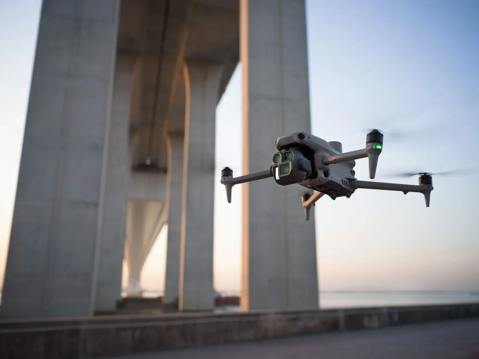 Image 14 of 19
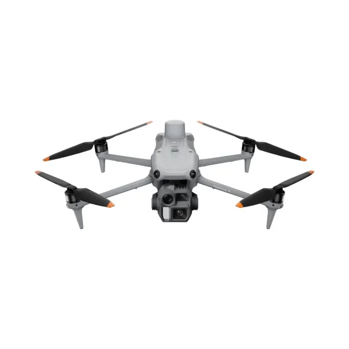 Image 15 of 19
 Image 16 of 19
 Image 17 of 19
 Image 18 of 19
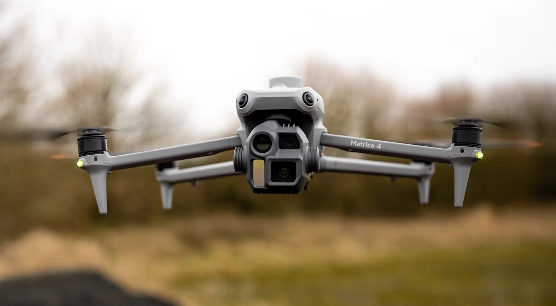 Image 19 of 19